
It took me about 10 minutes or so and it is fun to see where all I have recorded birds in eBird. You can go to my map by clicking here.
Anyways, here are some screen shots:


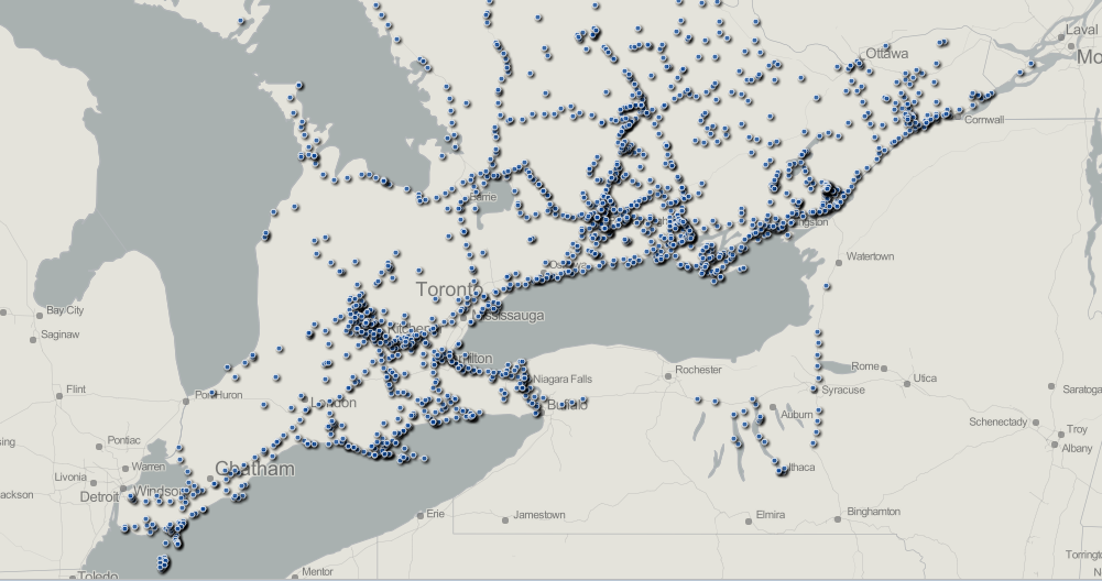
Looks like I still have lots of places to visit!
Here are detailed, step-by-step instructions:
Part 1: download your eBird data
1. sign in to eBird
2. click the "My eBird" tab
3. scroll down and click the "download my data" link from the right-hand margin (near the bottom)
4. wait ~5 minutes and you'll get an email with a link to download the data
Part 2: tweak it in Excel
1. open the csv file
2. select all of the data by clicking the corner between column A and row 13. click the data tab
4. click "remove duplicates"
5. click "unselect all" from the remove duplicates dialog box that opens
6. check the "my data has headers" checkbox
7. check the "submission ID" checkbox and then hit OK
8. delete all of the columns except location name, latitude, longitude and date
10. in the data tab click sort
11.
in the sort dialog box check the "my data has headers" then sort by the
data column (A to Z should be default). This step doesn't really matter
at all if you are just making the map...
12. in cell E1 type "checklists"
13. in cell E2 type "=Countif(A:A,A2)" (remove the quotes)12. in cell E1 type "checklists"
14. copy cell E2 and paste it into all of the other cells in column E (down to your last row)
15. copy column E by clicking the E at the top
16. right-click on E and click "paste special" and select values
17. go through steps 3-7 to remove duplicate locations
18. go through steps 9-11 to sort by checklist
19. now save the file as something in a location you will remember. be sure to keep it as a .csv file.
Part 3: map it
go to geocommons.com and sign in/sign up
1. click "upload data"
2. scroll down and click "upload files from you computer"
3. click "add file"
4. find the file and add it
5. once you get the complete message, click "next"
6. click "next step" to georeference your data
7. click the "locate using the latitude and longitude columns" button
8. click the "continue" button
9.
after a short wait to process the data you'll move to the next screen
("review your geodata") - click the "continue" button to move on
10.
on the next screen you can give you data set a name and add a
description (all optional). if you want your data (and map(s)) to be
public be sure that "access" and "find" are checked off beside "everyone
may:" under the heading "Who may access this data?" Alternatively if
you don't want it to be public make sure those are not checked. Once
you're ready, scroll down and hit "save"
11. Now you should see your data on a map. To make a map that you can edit, click the "Map Data" button
12.
On your map screen (may take a few seconds to load all of your data)
you will now have options in a "style" toolbar to edit what the symbols
look like, plus you can edit your maps name. Once you are done making
your map pretty click the "save" button.
13. Once your map
is saved you can just copy the url and share that with people (if you
made it public), or you can click the "PrtSc" button on your keyboard to
copy your screen view and paste that into a program like Paint.There are a couple other, even simpler ways to make these maps! Thanks to Jeff Skevington for this one:
1. download your eBird data (as described in part 1, above).
2. delete all columns except latitude and longitude.
3. highlight all of the records (see part 2, step 2 above)
4. remove duplicates (see part 2, step 3-6 above)
5. copy all coordinates from the two columns
6. go to http://www.simplemappr.net/
7. create a login
8. paste the data into the point data tab
9. click on preview tab and refresh
10. position map and choose projection
11. click download and choose your preferred file type.
I think you can also now use the new Google Maps to do this- just save a spreadsheet with latitude and longitude and import it.
Wow, I need to make my NL map look like your Southern Ontario map!
ReplyDeleteThese are nice recipes, thanks. Of minor note, there's no need to remove duplicates prior to pasting into SimpleMappr - duplicates get lumped together under a single marker so there's no performance gain. Another nice resource for online maps is http://batchgeo.com/.
ReplyDelete